
Where is the best land to mine silver in Texas? The most credible answer is the Shafter area in Presidio County, inside the Trans-Pecos region of Far West Texas. That is where Texas’s best-known silver mining district developed, and the Presidio Mine became the state’s standout silver producer. But there is an important catch: the best silver-bearing ground is not always the best land you can legally access or realistically prospect. In Texas, private ownership, mineral rights, state land rules, and federal mining-claim status matter almost as much as geology. The strongest article on this topic has to answer both parts of the question: where silver has historically been found and how to tell whether a parcel is actually usable today. TSHA identifies the Shafter District as the major historic silver district in Texas, while the Texas General Land Office and BLM make clear that access depends on the type of land and whether it is open to prospecting or mineral entry.
Why Shafter and Presidio County are usually the first answer
When people ask where to find silver in Texas, they are usually pointed toward Shafter for a reason. The Shafter Mining District in south-central Presidio County was mined for silver and related ores from 1883 until 1952, and TSHA describes it as a district with fifteen prospects. The district stretched from the Chinati Mountains toward the Rio Grande and included the famous Presidio Mine, which became the center of Texas silver production.
That history matters for SEO and for real-world prospecting. If someone wants the best locations to find silver in Texas, they are not usually looking for a random modern parcel. They want the best-known silver-bearing district, and on that basis Shafter is the strongest answer. TSHA’s broader entry on silver mining in Texas also shows why: the five silver mining districts of the Trans-Pecos region included the Shafter District in Presidio County, the Van Horn-Allamoore District, the Plata Verde District, the Quitman Mountains District, and the Altuda Mountain District. That makes Presidio County silver the clearest lead, but it also places Shafter inside a larger West Texas mineral belt rather than treating it as an isolated site.
There is another reason Shafter dominates this topic. The place combines history, named mines, documented production, and a recognizable geographic identity. That is much stronger than vague claims about “silver somewhere in West Texas.” For a reader, Shafter is the answer that turns a fuzzy query into a real location. For a writer, it is the anchor that lets the article cover Texas silver mining, Trans-Pecos geology, and land access rules without drifting.
Where silver has historically been found in Texas beyond Shafter
Even though Shafter is the headline location, it is not the only place connected to silver occurrences in Texas. TSHA says the main silver activity was concentrated in the Trans-Pecos region, and specifically names several districts and mines beyond Presidio County. Those include the Van Horn-Allamoore District in Hudspeth and Culberson counties, the Plata Verde District, the Quitman Mountains District in Hudspeth County, and the Altuda Mountain District in Brewster County. Mines associated with Texas silver production included the Presidio Mine, Hazel Mine, Sancho Panza Mine, Black Shaft Mine, Plata Verde Mine, and Bird Mine.
That broader list matters because many users searching best places to find silver in Texas are really asking a second question too: what county or district should I research first? If the goal is major silver mining districts in Texas, then the smart path is to start with Presidio County, then expand into Hudspeth, Culberson, and Brewster as secondary targets. TSHA also notes that between 1885 and 1955, Texas produced 32,663,405 troy ounces of silver, which shows that the state did have meaningful silver output, even if it never became a modern silver giant like Nevada.
A simple comparison helps:
| District / Area | Why it matters | Best use for readers |
| Shafter District, Presidio County | Best-known historic silver district in Texas | Start here for history, geology, and serious research |
| Van Horn-Allamoore District | Documented silver-producing district in West Texas | Strong secondary research target |
| Plata Verde / Quitman Mountains | Historic silver occurrences in Hudspeth-Culberson area | Useful for broader county-level study |
| Altuda Mountain District, Brewster County | Historic silver production area | Good support topic for regional context |
These places support the article’s topical authority because they help answer which Texas counties produced silver, not just where to mine silver in Texas.
What makes land “best” for silver in Texas
This is where many articles fall short. The best land for silver is not simply the place with the most famous mining history. It is the place where three things line up: silver-bearing geology, legal access, and realistic prospecting value.
The geology side is relatively straightforward. BLM’s mining guidance classifies silver, lead, copper, and zinc as locatable minerals on eligible federal lands, and TSHA’s Texas mining history shows that many silver-producing areas in West Texas were tied to broader hard-rock mineral systems rather than easy, shallow surface finds.
The access side is harder. Texas is not a state where you can casually assume that promising ground is open. A famous district may sit on private ranch land, on state land with a lease framework, or on land where federal mineral entry is limited or closed. The Texas General Land Office says it issues prospect permits and leases on state lands for hard minerals, and that exploration and leasing differ depending on the type of mineral and the type of land. BLM says mining claims can be located only on open public land and not in areas closed to mineral entry.
The practical side matters too. A district can be silver-rich on paper yet still be a poor target for a hobby prospector because the ore was historically extracted from underground mines, not from easy surface material. In Texas, the best silver district is often best understood as a research target first and a field target second.
Can you legally mine or prospect for silver in Texas?
The short answer is sometimes, but the rules depend on who owns the land, who owns the minerals, and whether the land is under a system that allows mineral entry or leasing.
On private land, you generally need permission from the landowner, and in Texas that may still not be enough if mineral rights are severed from the surface estate. A person can own the surface and not own the minerals underneath. That is why surface rights vs mineral rights in Texas is not just legal jargon. It is one of the most important practical issues for anyone asking how to verify mineral rights before prospecting in Texas. The Texas General Land Office’s hard-minerals page shows that state lands are handled through prospect permits and leases, not through casual public collecting assumptions.
On federal land, BLM says a mining claim is a parcel where a claimant has asserted a right of possession and the right to develop and extract a discovered valuable mineral deposit. BLM also says claims are for locatable minerals such as gold, silver, lead, and copper, but only on lands open to mineral entry. Before locating a claim, BLM says a prospector should check BLM records for prior recorded claims and also check for existing claim markings on the ground.
That means the real-world answer to can you mine silver on public land in Texas is not “yes” or “no” in the abstract. It is: only on land where the legal framework allows it, and only after checking status, claims, and ownership. For most readers, the practical lesson is simple. Never assume that a promising district equals open land.
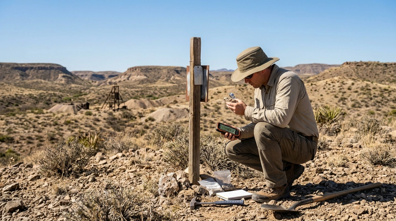
How to check whether a piece of Texas land is actually worth researching
A smart silver prospector in Texas starts with a desk workflow, not a shovel.
First, confirm that the location sits inside a documented silver district or near a known silver-producing mine. TSHA’s entries on Shafter Mining District, silver mining, and mineral resources and mining are useful starting points because they name the districts, counties, and mines tied to historic production.
Second, check land ownership and whether you are dealing with private land, state land, or land that may involve federal mineral entry. If it is state land, the Texas General Land Office is the key source for the hard-minerals framework. If it is federal land, the BLM mining claims system and claim-location guidance matter.
Third, separate historical significance from current usability. A historic mine reference does not mean you can legally walk in, collect ore, or stake anything. Many readers searching how to research historic silver mines in Texas get stuck here. The best approach is to treat old mine names as research clues, not automatic permission slips.
A practical checklist is helpful:
- Is the district historically silver-bearing?
- Who owns the surface?
- Who owns the minerals?
- Is the land open to mineral entry or leasing?
- Are there existing claims, permits, or restrictions?
- Is the site safe and realistically accessible?
That checklist answers the real search intent better than a simple place list ever could.
What silver looks like in the field
For many readers, what to look for is just as important as where to look. In Texas, hobbyists are often more likely to encounter silver-bearing minerals than bright, obvious native silver. Historically, Texas silver production was commonly associated with broader ore systems, which is one reason terms like silver-bearing galena, lead, zinc, and ore belong naturally in this topic. TSHA’s district-based history supports that broader hard-rock context.
That means you may be looking for galena, argentite, or other silver-associated mineralization, not movie-style gleaming nuggets. Metallic luster, host rock, and district history matter more than wishful thinking. A beginner asking how to identify silver-bearing galena should understand that field identification is only the first step. If the location is outside a documented silver belt, the sample may be far less meaningful than the finder hopes.
This is also where expectations matter. In Texas, especially around the Trans-Pecos, the better answer is often “look for signs of a silver system” rather than “look for pure silver.”
Best types of places to check on the ground
Once the research is done, certain kinds of sites make more sense than others. Historic mine dumps, old mine workings, nearby outcrops, and altered rock zones are often more promising than random open ground. TSHA’s district and mine lists make these old workings important context, even when they are not open or safe to enter.
Some readers also search for creeks, stream banks, gravel, and alluvial deposits. BLM’s minerals overview notes that some locatable minerals can occur in placer form, but that does not mean Texas is a classic silver placer state.
So where should a hobbyist focus? Usually on places that combine:
- documented silver history
- visible mineralized rock or mine-related material
- clear legal access
- reasonable safety conditions
That is why old mine areas and mine dumps tend to sound attractive in SEO content but also require caution. They can be useful as research markers, yet they can also be dangerous, private, or both.
Tools, safety, and realistic expectations
A good field kit for recreational prospecting in Texas is simple: gloves, eye protection, a rock hammer, a small chisel, sample bags, a notebook, a GPS app, and a basic field guide. The point is not to overcomplicate the outing. It is to collect observations, not to act like an industrial miner.
Safety matters more than many casual articles admit. Old silver districts can include unstable ground, hidden shafts, sharp metal, and contamination concerns around historic workings or tailings. Even if a site looks abandoned, it may still be dangerous or legally off-limits. BLM’s claim guidance and the Texas state-land framework both reinforce the idea that legal status comes before collecting.
There is also a mindset issue. Many people searching where can hobby prospectors look for silver in Texas are hoping for a quick, high-value find. A better expectation is this: Texas silver prospecting is usually about studying a district, recognizing mineral associations, and maybe finding interesting specimens, not getting rich in a weekend.
Is silver mining in Texas still active, and does that affect where to look?
Historic fame and current activity are not the same thing. TSHA’s older silver-mining entry says there was no silver mining in Texas as of 1994, reflecting the historical context of that source. KPBS later reported on the Shafter silver mine shutdown in 2013, showing that mine activity and economics can shift over time.
That is important because a reader may see a famous mine name and assume it is either actively producing or easy to access. Neither assumption is safe. A district can remain the best historical silver district in Texas while still being a poor or restricted place for a hobbyist to visit. Industrial mining depends on equipment, financing, labor, safety, and silver prices. Hobby prospecting depends on something different: legal access, surface clues, and realistic expectations.
In plain English, active mine news should change how you interpret a place name. It should not automatically tell you where you can go.
A quick case study: why Shafter wins the keyword, but not every user
If you judge the topic by historical authority, production scale, and name recognition, Shafter wins. TSHA ties Shafter directly to the main Texas silver story, and other Texas mining references place the state’s notable silver production in the same broader West Texas belt.
If you judge the topic by ease of hobby access, the answer becomes less clear. A hobbyist may be better served by researching county-level geology, legal access, and visible surface mineralization than by driving toward the most famous historic district with no plan. That is the gap most competing articles miss, and it is the reason the best answer to where is the best land to mine silver in Texas is really two answers:
Best known silver district: Shafter / Presidio County
Best land for you personally: the land that is silver-bearing, legally accessible, safe, and worth your time to research
FAQ: best land to mine silver in Texas
Is Shafter the best place to find silver in Texas?
Historically, yes. It is the strongest single answer because of the Shafter Mining District and the Presidio Mine.
Can you prospect on public land in Texas?
Only if the land’s legal status allows it. On federal lands, BLM says claims can be located only on lands open to mineral entry, and existing claims must be checked first.
Do you need permission on private land?
Yes, and you may also need to understand who owns the mineral rights, not just the surface. Texas land status is a major part of this topic.
What county has the strongest silver history in Texas?
Presidio County is the leading answer because of Shafter and the Presidio Mine.
What minerals should you look for with silver?
Often silver-bearing galena, broader lead-zinc mineralization, and other signs of a hard-rock ore system rather than pure native silver.
Can hobbyists realistically find silver in Texas?
They can research promising areas and potentially find interesting mineralized specimens, but Texas is usually a research-heavy prospecting state, not an easy silver-collecting state.
Conclusion
The best answer to where is the best land to mine silver in Texas is still the Shafter area in Presidio County, with the wider Trans-Pecos region as the broader silver belt. That is where Texas’s silver history is strongest, where the state’s best-known silver mining district developed, and where the most authoritative historical sources point first. But the smartest version of this answer goes further. The best silver land is not just the place with the biggest mining history. It is the place where geology, legal access, mineral ownership, and realistic field conditions all line up. In Texas, that extra layer matters a lot. So start with Shafter, expand into the other named West Texas districts, and then verify the land before you ever treat a historic map like an invitation.
Disclaimer: This article is for general informational and entertainment purposes only. Interpretations of books, movies, and religious themes may vary among readers and viewers. For official details, refer to the original creators and published sources.